| Programming | |
Using the HDF4 Import Tool Subsetting Options
When you select a data set, the Importing and Subsetting pane displays the subsetting options available for that type of data set. For data sets that support multiple, mutually exclusive subsetting options, like HDF-EOS Grid data, the contents of the Importing and Subsetting pane change when you select one of the options. The following sections describe these subsetting options for all supported data set types. For general information about the tool, see Using the HDF Import Tool.
Note
To use these data subsetting options effectively, you must understand the HDF and HDF-EOS data formats. Use this documentation with the HDF documentation available at the NCSA Web site (hdf.ncsa.uiuc.edu) and the HDF-EOS documentation at the NASA Web site (hdfeos.gsfc.nasa.gov/hdfeos/index.cfm).
|
HDF Scientific Data (SD)
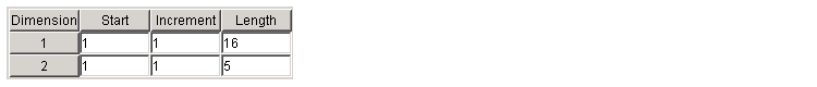
HDF Scientific Data (SD) data sets are multidimensional arrays. You can import a subset of an HDF SD data set by specifying the location, range, and values to be read from the data set.
The HDF Import Tool displays the subsetting options available, where each row represents a dimension in the data set and each column represents these subsetting parameters:
HDF Vdata
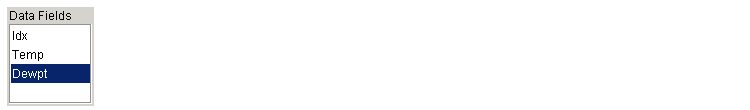
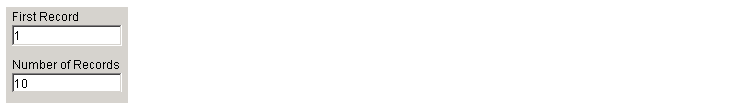
HDF Vdata data sets are tables. You can import a subset of an HDF Vdata data set in two ways:
Fields. Select a specific field you want to import.
Records. Specify the range of records you want to import.
HDF-EOS Grid Data
In HDF-EOS Grid data, a rectilinear grid overlays a map. The map uses a known map projection. The HDF Import Tool supports the following mutually exclusive subsetting options for Grid data:
Direct Index. You can import a subset of an HDF-EOS Grid data set by specifying the location, range, and values to be read along each dimension.
Each row represents a dimension in the data set and each column represents these subsetting parameters:
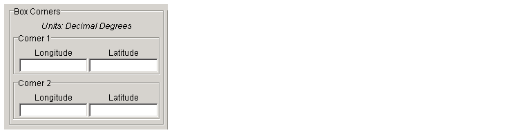
Geographic Box. You can import a subset of an HDF-EOS Grid data set by specifying the rectangular area of the grid that you are interested in.
You define the rectangular area of interest by specifying two points that are two corners of the box:
When specifying geographic box subsetting, you can optionally further define the subset of data you are interested in by using Time parameters (see Time) and by specifying other User-Defined subsetting parameters (see User-Defined).
Interpolation. Interpolation is the process of estimating a pixel value at a location in between other pixels. In interpolation, the value of a particular pixel is determined by computing the weighted average of some set of pixels in the vicinity of the pixel.
You define the region used for bilinear interpolation by specifying two points that are two corners of the interpolation area:
Pixels. You can import a subset of the pixels in a Grid data set by defining a rectangular area over the grid.
You define the box by specifying two points that define two corners of the box:
Tile. In HDF-EOS Grid data, a rectilinear grid overlays a map. Each rectangle defined by the horizontal and vertical lines of the grid is referred to as a tile. HDF-EOS Grid data can be stored as tiles. If it is, you can import a subset of the Grid data set by specifying the coordinates of the tile you are interested in.
Tile coordinates are 1-based, with the upper-left corner of a two-dimensional data set identified as 1,1. In a three-dimensional data set, this tile would be referenced as 1,1,1.
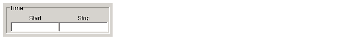
Time. You can import a subset of the Grid data set by specifying a time period.
Along with these time parameters, you can optionally further define the subset of data to import by supplying user-defined parameters (see User-Defined).
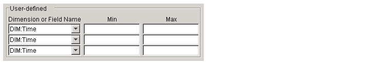
User-Defined. You can import a subset of the Grid data set by specifying user-defined parameters.
DIM:.
HDF-EOS Point Data
HDF-EOS Point data sets are tables. You can import a subset of an HDF-EOS Point data set by specifying any of these parameters:
Fields. Select a specific field you want to import.
Rectangular Area. You can import a subset of an HDF-EOS Point data set by specifying the rectangular area that you are interested in.
You define the rectangular area of interest by specifying two points that are two corners of the box:
Records. Specify the range of records you want to import.
Time. You can import a subset of the HDF-EOS Point data set by specifying a time period.
HDF-EOS Swath Data
HDF-EOS Swath data is data that is produced by a satellite as it traces a path over the earth. This path is called its ground track. The sensor aboard the satellite takes a series of scans perpendicular to the ground track. Swath data can also include a vertical measure as a third dimension. For example, this vertical dimension can represent the height above the Earth of the sensor.
The HDF Import Tool supports the following mutually exclusive subsetting options for Swath data:
Direct Index. You can import a subset of an HDF-EOS Swath data set by specifying the location, range, and values to be read along each dimension.
Each row represents a dimension in the data set and each column represents these subsetting parameters:
Geographic Box. You can import a subset of an HDF-EOS Swath data set by specifying the rectangular area of the grid that you are interested in. When you use this subsetting method, you can also specify the Cross Track Inclusion Mode and the Geolocation Mode.
Define the area by specifying two points that specify two corners of the box:
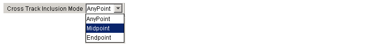
For Swath data, you must also specify the Cross Track Inclusion Mode. This determines how much of the area of the geographic box that you define must fall within the boundaries of the swath.
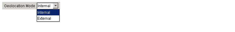
For Swath data, you must also specify Geolocation Mode. This specifies whether geolocation fields and data must be in the same swath.
Time. You can import a subset of the Swath data set by specifying a time period.
When you use this subsetting method, you must also specify the Cross Track Inclusion Mode and the Geolocation Mode. You can optionally also specify user-defined subsetting options.
User-Defined. You can import a subset of the Swath data set by specifying user-defined parameters.
DIM:.
HDF Raster Image Data
No subsetting options are available for HDF raster image data.
| | Using the HDF Import Tool | Using the MATLAB hdfread Function | |
© 1994-2005 The MathWorks, Inc.